Make a Street Map in Minutes
Purpose of a Street Map
A street map graphically shows where your place locates. For business or institutions that are open to public, such as stores, restaurants, salons, etc., a well-prepared street map, whether shown on the website, or printed on the flyer, will be much helpful for potential visitors in navigating to your place.
An Easy Way to Create a Street Map
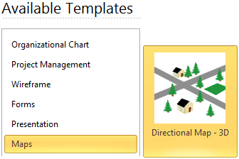
Start with the Exact Street Map Template
Directional Map Template in EdrawMax helps you easily create street maps using extensive built-in shapes and easy to use tools. From the starting page click Map, choose a 3D street map or 2D street map template to start. You will see an intuitive interface with abundant built-in symbols available for street map drawing.
Use Abundant Built-in Street Map Shapes
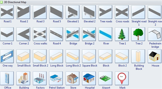
A large collection of pre-drawn shapes, including roads, trees and buildings for making street maps are available. All the symbols are in vector format for modification. Simply drag and drop any symbol you would like to use from the library pane. If you want to learn more on this part, please visit 2D Directional Map Symbols pages for more information. Below shows the 3D shapes.
Basic Steps
Step 1. Start a blank street map drawing page:
On the File menu, click New. Under template categories, point to Map, and double click Directional Map-3D template. A new drawing page will open.
Step 2. Create the road configuration:
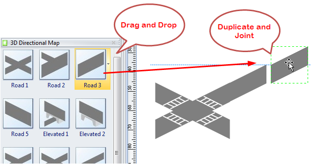
- Go to the library pane on the left of the canvas. From 3D Directional Map, drag road shapes onto the drawing page.
-
To make a longer road, duplicate the road shapes and joint the segments together.
(Note: a. You can press arrow key to nudge a shape into position. b. When a long road is created, you can use Group tool to group the multiple road shapes together as a single unit, so that you can use it again as one shape.) - Align the shapes to create the road configuration you want.
Step 3. Add more street map elements:
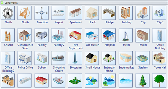
Drag more shapes from the library, such as bridges, rivers, buildings, cars and trees onto your map. Besides 3D Directional Map library, you might open other libraries to find required symbols.
(Relevant Libraries: 3D Directional Map, Landmarks, Map Vehicles)
Step 4. Mark your place:
From 3D Directional Map library, drag the Mark shape and drop onto the position you want to mark. Double click on the default text to edit your own text.
Step 5. Add text to shapes:
Double click on a shape, and a text box will appear, you can edit description to the shape.
Step 6. Print:
When a street map is done, it's easy to print and share with more people. On the file menu, point to Print to set for print options. You can change settings with fewer clicks and see the print preview in real time. Go to Print EdrawMax Diagrams for detailed information about printing.
Step 7. Export:
EdrawMax offers support for exporting your diagram to various formats, including Microsoft Office, PDF, and many other graphic formats. On the File menu, point to Export & Send for Export options. Find more instructions on Export EdrawMax to other Formats.
Street Map Examples
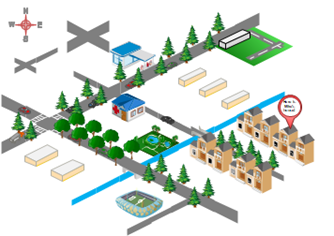
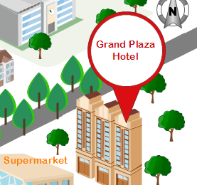
This street map example shows where the Hotel locates. You can click the picture to open a clearer image. It's also available to download and re-edited as a starting template.
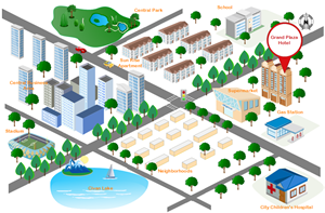
The right picture is a 2d street map which is easier to draw.
More Features Making EdrawMax the Best Street Map Software
- It has included a large amount of built-in shapes for drawing street maps.
- The program is easy to learn as it mimics Microsoft's Ribbon.
- All documents and symbols are vector objects with high clarity and available for reviewing and modifying.
- A set of smart tools are provided for automatic formatting. You can easily arrange, rotate, group and align objects with these smart tools.
- EdrawMax offers various customization options, using which you can adjust fill color, line width, line color, line style, font size, font style, text color, and much more.
- It's easy to add photos, images and edit text fields.
Some Useful Tips for Effective Street Map
1. It's important to include the most famous landmarks around your area.
2. Don't forget to add a North mark to indicate the north direction.
3. It's better to apply a striking color for the location mark, so that others could recognize your place at a quick glance.